Turkey-Syria Earthquake 2023

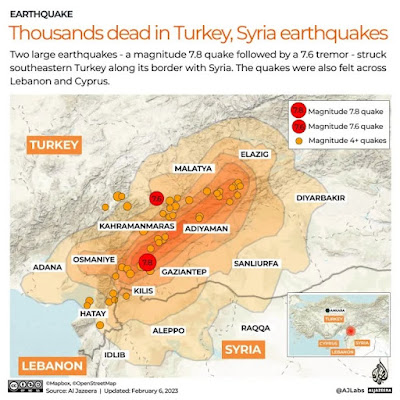
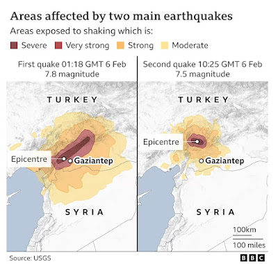
The Turkey-Syria Earthquake on 6 Feb 2023 has resulted in total death toll of more than 46,000 (as at 20 Feb 2023). An initial magnitude 7.8 earthquake hit near the southeastern Turkish city of Gaziantep at 4:17am local time (01:17 GMT) , as people were sleeping, at a depth of about 17.9km (11 miles).

When did the main earthquake occur? How does this impact on the extent of damage?

Where is the epicenter of the earthquake?

What are the factors which affect the extent of damage?

How effective are the short term responses?


www.aljazeera.com/amp/news/liveblog/2023/2/9/turkey-syria-quake-updates


https://www.ft.com/content/337edef6-05c9-498c-a3f0-13776082f218


The Arabian plate moving northwards and slide past the Anatolian plate. This resulted in the building of stress and the release of the stress lead to the land slipping and faulting occurs. 


https://www.aljazeera.com/amp/news/2023/2/8/infographic-how-big-were-the-earthquakes-in-turkey-syria


https://www.bbc.com/news/science-environment-64540696

Factors contributing to the extent of damage

1. The epicentre was about 26 km east of the Turkish city of Nurdagi.

2. The intensity of the earthquake was high at a magnitude of 7.8, amplified by the shallow depth of 18km, which caused many buildings to collapse. 

3. The time of occurrence as the incident occurred in the early hours of the morning at 4.17am, when people were inside the buildings and sleeping.

4. The sturdiness of the buildings as many of the infrastructure are not resistant to earthquake in South Turkey and especially Syria. There were weak enforcement of building codes and many violations including homes built without permits, buildings that added extra floors or expanded balconies without authorisation, and the existence of squatter inhabited by low-income families.

5. There had not been a major earthquake for more than 200 years or any warning signs, so the level of preparedness would be less compared to a region which is more used to dealing with tremors.


Impacts


The rift created by the earthquake in a former olive field.

Damage to buildings and infrastructure as shown by drones.

Short term responses

At least 870,000 people urgently needed food in the two countries after the quake, which has left up to 5.3 million people homeless in Syria alone. Up to 23 million people could be affected by the massive earthquake that has killed thousands in Türkiye and Syria. Aftershocks following Monday's 7.8-magnitude tremor have added to the death toll and further upended the lives of survivors.

Rescuers in Turkey and Syria braved freezing cold, aftershocks and collapsing buildings, as they dug for survivors buried by a string of earthquakes.

WHO is mobilising emergency supplies and emergency medical teams to provide essential health care for the injured and most vulnerable.

https://www.channelnewsasia.com/world/turkiye-turkey-syria-earthquake-could-affect-23-million-who-3260171?cid=internal_mcdrecs_11022023_cna#mdcrecs_s


https://www.todayonline.com/world/death-toll-turkey-syria-quake-tops-33000-turkey-starts-legal-action-against-builders-2106316?cid=internal_mcdrecs_15022023_tdy#mdcrecs_s


Food, warm clothing and tents for the victims of the earthquake. 


Many countries, including Singapore, sent rescue teams.


Another earthquake hit Turkey Syria on 20 Feb


Read Users' Comments (2)

Cyclone Gabrielle struck New Zealand

Cyclone Gabrielle struck New Zealand on 14 Feb 2023.


How did the cyclone form? 

Where are the areas affected by the cyclones?

What are the economic, social and environmental impacts of the cyclone?

https://www.dailymail.co.uk/sciencetech/article-11748949/amp/Map-reveals-Cyclone-Gabrielles-trail-destruction.html

Read Users' Comments (0)

Population in a circle

This interactive map is tons of fun! It calculates population around any point. There are 405,152 people a 3km radius in the Punggol-Sengkang, which shows how densely populated the area is.

Look at the transport amenities - 239 bus stops and 28 metro and train stops (MRT and LRT stations).

How does this show economic sustainability of an urban neighbourhood?

Locate another point on the interactive map e.g. an area in central Africa. 

Why would the population size be lower and fewer transport amenities avai6?

 Click here to explore the interactive map: https://www.tomforth.co.uk/circlepopulations/ 


Read Users' Comments (0)

Global warming

Study the graphs and diagrams below from The Straits Times 9 Feb 2023.


What is the relationship between the greenhouse gases and ocean heat content change?


Why is sea-level rise disastrous?


Why is the increase in surface temperatures disastrous?


What is extreme weather?
How does it impact on countries?
Why is the shrinking Arctic sea ice a concern?


Read Users' Comments (0)