Food Security in Singapore

In land scarce Singapore, vertical farming is one way to achieve food security. Read more on the update.

How does vertical farming help to achieve food security?

Why is there a need to achieve 30% self sufficiency by 2030?

What other strategies can help Singapore achieve 30by30?

https://www.businesstimes.com.sg/government-economy/singapores-urban-farmers-can-offer-their-solutions-overseas-chan-chun-sing

More urban farms at HDB carpark roof top


Sustainability in food production


Ensuring food security in Singapore

Meeting Singapore 30 by 30  food goal


Read Users' Comments (0)

Climate Change threatening Singapore

TV commercial by PUB

Extreme weather due to climate change threatening Singapore


What contribute to climate change?
Why is climate change a threat to Singapore?
How can we play a part in mitigating climate change?

https://www.channelnewsasia.com/news/singapore/pub-campaign-fight-climate-change-threat-weather-coastlines-14360794


A good Google Earth app to show how climate change can impact on coastal cities other than Singapore.

Read Users' Comments (0)

Mt Sinabung erupted 2 March 2021

 Watch the eruption time lapse from BBC below.

 
What cause volcanic eruptions?
Why do people live near volcanic areas?
How can the impacts be mitigated?


The 2014 eruption in Feb resulted in 16 deaths and thousands displaced.

Refer to the map below.

How is the Sumatra Trench formed?
Bukit Barisan is a fold mountain. 
What cause fold mountains to be formed?
Why are there so many volcanoes on Sumatra??


Read Users' Comments (0)

Deaths from COVID-19 in US

A powerful graphic by the New York Times on the deaths as a results of the COVID-19 Pandemic in the US. Every dot represents a life lost and almost half a million lives have been lost from 24 April 2020 to 20 Feb 2021. The greater intensity as shown by number of dots (loss of lives) is in Jan 2021.


What is a pandemic?
When did the pandemic spread to US?
Why did the pandemic spread so quickly?
Who are the ones most affected by the pandemic?
What are the social and economic impacts of the pandemic? 
How effectives are the measures taken to deal with the pandemics?


Read Users' Comments (0)

Singapore Green Plan 2030

The Singapore Green Plan 2030 seeks to rally collective action to tackle climate change, and to make Singapore a greener and more liveable home. The Singapore Green Plan 2030 contains targets that will strengthen Singapore’s commitment to the United Nation’s 2030 Sustainable Development Agenda and Paris Agreement as well as help achieve Singapore's long-term, net-zero emissions goal!


Click on the images below for higher resolution


https://www.channelnewsasia.com/news/singapore/singapore-green-plan-2030-targets-10-years-14161356

The Green Plan has five key pillars:

a) City in Nature: to create a green, liveable and sustainable home for Singaporeans;

b) Sustainable Living: to make reducing carbon emissions, keeping our environment clean, and saving resources and energy a way of life in Singapore;

c) Energy Reset: to use cleaner energy and increase our energy efficiency to lower our carbon footprint;

d) Green Economy: to seek green growth opportunities to create new jobs, transform our industries, and harness sustainability as a competitive advantage; and

e) Resilient Future: to build up Singapore’s climate resilience and enhance our food security

ttps://www.mnd.gov.sg/newsroom/press-releases/view/singapore-green-plan-2030-charts-ambitious-targets-for-next-10-years-to-catalyse-national-sustainability-movement-1

Why is there a need for the Singapore Green Plan?

What are the main measures in the Singapore Green Plan 2030?

How does the Green Plan help in sustainable development?

Let's look at Energy Reset, reducing our carbon footprint by using alternative energy and energy efficient ecotown. 


What can you do to help?

https://storymaps.arcgis.com/stories/8634cd48b463400091e8fdfd14c57d32


Read Users' Comments (0)

Mt Merapi erupts

 Mt Merapi erupted on 27 Jan 2021. Watch the video to understand the formation and hazards of the volcano. 


Where is Mt Merapi located?
When was the volcano Mt Merapi formed?
How was Mt Merapi formed?
What is released during the volcanic eruption?
Why is the eruption explosive and hazardous?


Read Users' Comments (0)

Conservation vs Development

Should the Dover forest be cleared for housing development or be conserved? 
Where is the Dover forest located? 
When did the secondary forest start growing?
Who are the one against clearing the forest for housing development? 
Why are they against clearing the forest? 
How will the removal of the forest for housing development affect the environment?


Visit the link below to find out more:

More on the plan for Dover forest..
Human centred or nature centred views

A good article showing before and after images of  forest and mangroves which has been cleared for development in Singapore.

https://thekopi.co/2021/01/25/pictures-show-how-deforestation-has-changed-singapore/

The Dover Forest which was in the spotlight as the Nature Society of Singapore appealed for it to be conserve as there is plan to clear it for housing development.

https://www.channelnewsasia.com/news/commentary/dover-forest-singapore-conservation-nature-park-hdb-ura-14068618

Dover Forest 

Read Users' Comments (0)

Sulawesi earthquake

The epicenter of the 6.2-magnitudeearthquake, which struck at 1:28 am Jakarta time, was six kilometers (3.7 miles) northeast of the city of Majene, at a depth of 10 kilometers (6.2 miles), according to Indonesia's Meteorology, Climatology and Geophysics Agency.

Reflect on how the magnitude of earthquake, depth of focus, time of occurrence and population density affect the extent of damage.

As on 16 Jan 2021, 67 were killed as the earthquake resulted in the collapse of buildings and landslides. Many are still trapped in the rubble of collapsed buildings. Search and rescue, a short term response, is being carried out to save lives.

Aftershocks hamper rescue work.
What are aftershocks and how does it hamper search and rescue?
https://www.channelnewsasia.com/news/asia/indonesia-sulawesi-aftershock-earthquake-search-13973006


When did the earthquake occur?
What is the magnitude of the earthquake?
Why does the earthquake cause more damage on Sulawesi?
Indonesia is located along the Ring of Fire.
Where is the Ring of Fire?
Why are places located along the Ring of Fire prone to earthquakes?
How can the impact of the earthquake be mitigated?

“One of our biggest fears is exactly what’s going on right now – what happens when there’s a major event during a pandemic? It’s a perfect storm,” said Jan Gelfand of the International Federation of Red Cross and Red Crescent Societies.

“If you have people who are evacuated, the risk [of infection] for those people goes up tremendously,” said Gelfand. “You don’t want to put people in more danger than they are already in.”


A 5.7 magnitude earthquake struck off the northeastern coast of Taiwan on 9 Jan at a depth of 72km, with no reports of damage. 

Why do you think the extent of damage is lower compared to the one which struck Sulawesi?


https://earthobservatory.sg/blog/mw-62-earthquake-strikes-sulawesi


2018 Lombok earthquake


Read Users' Comments (0)

Climate Change Longest Day

 Watch the videos below on how millions of people in Asia’s cities, villages and coasts are affected by climate change.

Water shortage in the Mekong Delta and Jakarta


Farmers in Vietnam looking for solutions to long droughts, and families struggling with extreme heatwaves in Delhi's slums.


Coastal communities in Indonesia's Sumba island and the Sundarbans coping with rapidly rising sea levels,


Read Users' Comments (0)

Coping with floods in Singapore

Bishan-Ang Mo Kio Park was one of the places flooded from the heavy downpour on 1st Jan 2021.


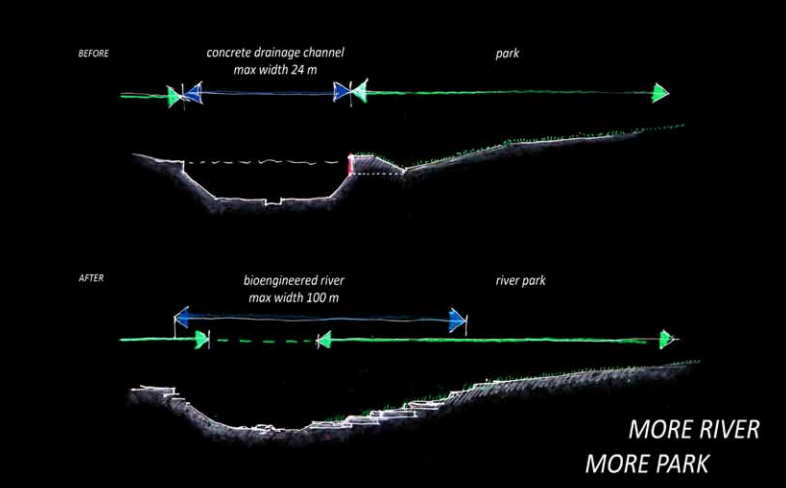
The 3.2km meandering naturalised river at Bishan-Ang Mo Kio Park used to be a 2.7km long straight concrete Kallang channel in the past, which would not otherwise have been able to contain as much rainwater as it now does.


The video below shows the amazing transformation of Bishan-Ang Mo Kio Park.


The 3.2km meandering naturalised river at Bishan-Ang Mo Kio Park used to be a 2.7km long straight concrete Kallang channel in the past, which would not otherwise have been able to contain as much rainwater as it now does.


Picture from Ramboll Studio Dreiseitl

Source: https://mothership.sg/2021/01/bishan-ang-mo-kio-park-flooded/


The river channel was redesigned to resemble a floodplain that connects to a network of drains in town. It is flooded during extreme wet weather

The usual volume of water will form only a narrow stream in the middle of the river while the adjacent area doubles up as a conveyance channel to dissipate large amounts of rainwater downstream in the event of a storm. After the redevelopment, the naturalised river's carrying capacity increased by 40 per cent, with an increase in length from 2.7km to 3.2km, as well as an increase in width by almost five times.


"Flooding" of Bishan-Ang  Kio Park 1 Jan 2020


PUB has issued flood risk warnings for several locations including Lorong Halus, Pasir Ris Farmway 3, Jalan Seaview, Mountbatten Road and the junction of Bedok Road and Upper Changi Road East, as the heavy rain from 1st to 2nd Jan 2021 haa caused water levels in the drains and canals to exceed 90% capacity. 

PUB’s Quick Response Teams were deployed to direct traffic and render assistance to residents in the areas stated above to protect them from flood risk. For example, officers helped residents in Mountbatten and Jalan Seaview to install inflatable flood bags to protect their homes. 


The highest total amount of rainfall since 1 Jan 2021 (as at noon on 2 Jan 2021) recorded at Changi was 318.6mm, which is more than the equivalent of the average monthly rainfall for January (238.3mm).


The heaviest rainfall of 184.4mm was also recorded at Changi on 2 Jan from 12am to noon. This amount is more than half of Singapore's average monthly rainfall in January, and lies within the top 1 per cent of maximum daily rainfall records for the past 39 years.


Source: https://m.facebook.com/story.php?story_fbid=3540978622659460&id=109647569125933

Check out the new flood protection barrier, Floodgate, which can be quickly deployed to protect homes and buildings in the event of a flash flood. It is made from high-strength steel frames wrapped in a waterproof rubber sleeve which is expandable and can be installed at the entrances of residential, commercial and industrial premises.


https://www.straitstimes.com/singapore/pub-trials-new-flood-protection-barrier-in-preparation-for-monsoon-season


Why does Singapore experience greater amounted of rainfall in Dec and Jan?

How does flash flood occur?

Where are the areas most affected by flash floods?

What are the measures taken to mitigate the impacts of flood?

Read Users' Comments (0)